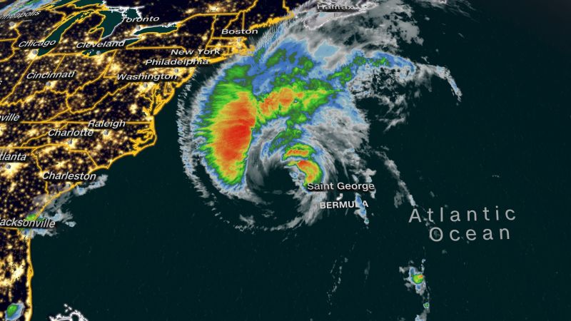
Hurricane Lee is expected to lash parts of coastal New England and Atlantic Canada on Friday with heavy rain and strong winds that could lead to flooding in some areas and knock out power across communities.
Inland areas of New England are not expected to see significant storm impacts as Lee’s core is on track to continue churning off the US East Coast.
Still, the massive storm could drench portions of eastern New England into portions of the Canadian province of Nova Scotia with up to 4 inches of rain beginning Friday night into Saturday. Lee’s mammoth size will allow its strong winds to knock down power lines and possibly cause some flooding.
The Canadian Hurricane Center issued a tropical storm warning for New Brunswick from the US-Canada border to Fort Lawrence, including Grand Manan Island, the National Hurricane Center said late Thursday. Another tropical storm warning is also in effect for the coast of Nova Scotia from Fort Lawrence to Point Tupper.
Tropical storm conditions – winds of at least 39 mph – are expected to start in southern New England on Friday afternoon, the hurricane center said.
By early Friday morning, beach conditions continued to deteriorate as dangerous rip currents and surf were ongoing along much of the East Coast, the hurricane center said.
As Lee approached the New England coast, Maine Gov. Janet Mills declared an emergency Thursday, requesting federal aid in preparation for the storm.
The center of Lee, a Category 1 hurricane, was about 215 miles northwest of Bermuda as of early Friday, carrying maximum sustained winds of 85 mph, the hurricane center said at 5 a.m. ET.
Lee whipped strong winds and tropical storm conditions in Bermuda throughout Thursday, triggering power outages on the island. Those weather conditions are expected to continue through Friday morning, and an island-wide tropical storm warning is in effect as the hurricane treks west of Bermuda.
Meanwhile in the US, a combination of hurricane and tropical storm alerts are in effect for many New England coastal communities in anticipation of Lee’s potential impacts Friday and through the weekend.
A tropical storm warning issued along New England’s coast was extended northward to the US and Canada border, the hurricane center said Thursday.
Another tropical storm warning in effect for the coast of Massachusetts was also extended westward to Westport, the agency added. Martha’s Vineyard and Nantucket are included in the warning area.
Additionally, a hurricane watch is in effect for Petit Manan Point, Maine, to the Canadian border.
Forecasters expect Lee to weaken as it nears land. But because it’s already a massive storm in size, its strong winds have the bandwidth to batter coastal New England and Canada’s Atlantic provinces.
Hurricane-force winds extended up to 105 miles from its center and tropical storm-force winds stretched for up to 320 miles, the hurricane center said early Friday.
On Saturday, hurricane-strength winds (at least 74 mph) are possible from the northern coast of Maine into portions of the Canadian provinces of New Brunswick and Nova Scotia. But tropical storm-force wind gusts are possible across a much larger area of New England and Atlantic Canada.
Provincial and wildlife parks in Nova Scotia will close Friday as Lee inches closer to the area.
“Safety is our priority as we prepare for storm conditions forecast for the weekend,” said Tory Rushton, provincial minister of natural resources and renewables. “We are closing our parks for the storm and will reopen when it is safe.”
Lee is expected to dump its heaviest rain load over Maine on Saturday. Neighboring states including New Hampshire, Massachusetts and Rhode Island could also see rainfall from Lee.
Over the weekend, communities from Rhode Island to northern Maine may see 1 to 2 inches of rain. Another 2 to 4 inches of rainfall may impact the Massachusetts Cape and much of Maine. Recurrent downpours could boost rainfall totals to 6 inches.
