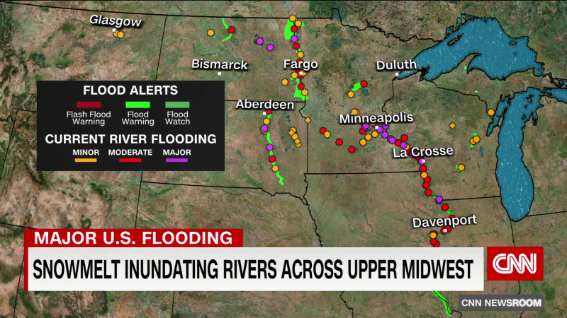
Twenty river gauges are in major flood stage across the Midwest, with more potentially damaging flooding expected in the coming days and weeks as the snow from this year’s blockbuster season continues to melt.
This year’s river rise could lead to some of the worst flooding in 20 years in some places, with most river gauges in major flood stage along the Mississippi River from St. Paul, Minnesota, to Davenport, Iowa. It follows this winter’s relentless parade of storms soon after the Mississippi River near Memphis had dropped to record low levels from drought.
Now, the Mississippi River at La Crosse, Wisconsin, is forecast to crest near 16.1 feet Wednesday into Thursday – which would be its third-highest crest there and not far off the record of 17.89 feet set in April 1965. At 16 feet, “water is within one foot of Rose Street near Interstate 90, and the eastbound I-90 exit may be closed,” the National Weather Service said.
“We’re expecting a pretty good crest in a week,” Matson said Tuesday. “Whether it’s a record crest or close to a record, there’s not definitive answers yet. But it doesn’t really matter for us because we fight the river.”
Near Davenport, the Mississippi River is already at major flood stage, topping 18 feet with perhaps another 3 feet to go by early next week – which would be just a foot shy of that all-time record. Several gauges to the north, near Dubuque, Iowa, also are forecast early next week to reach their third-highest crest ever, behind 1965 and the river floods in 2001, the local weather service office said.
“We’ve used the lessons learned and the forensic analysis that the (US Army) Corps of Engineers gave us to set the barriers and set the pumps, and we have public works people doing 24/7 shifts,” Matson said. “We’re fully engaged, so we’ll see where Mother Nature and the Mississippi decides to go.”
Here is the current forecast for potential crest heights on the Mississippi River along with a flood category forecast through April 30. pic.twitter.com/Fcnynyw2S7
— NWS Quad Cities (@NWSQuadCities) April 24, 2023
Widely changing temperatures put runoff in flux
Flood warnings now are in place for rivers in the Upper Midwest from the US-Canadian border to north of St. Louis, and such warnings extend more than 400 miles along the Mississippi River alone.
As much of the snow has melted in the Upper Midwest, the resulting swell of water upstream will creep south, causing a slow rise and fall of gauges. In the next few days, nearly 15 more gauges will be added to the list of those in major flood stage as the snowmelt causes a slow rise in the rivers downstream.
“It takes time for that water to make it to the river. It’s not all going into the river all at once. It’s just a longer process,” said Caleb Grunzke, meteorologist with the Twin Cities weather service office.
Unlike flash flooding, which can happen in seconds, seasonal spring river flooding is gradual, though last week’s relative heat wave across the Midwest – with temperatures in the mid-80s to 90 degrees – will “just accelerate the melting,” he said.
“It’s above freezing the whole day, so snow is continually melting over that whole week and you’re getting lots of runoff into the rivers very quickly,” Grunzke explained.
Much cooler temperatures – with dips below freezing overnight – have settled in this week, melting the snow more gradually and “slow(ing) down the amount of runoff that goes into the rivers,” he said.
Exceptional snowfall recorded
Several cities in the Upper Midwest this winter have seen exceptional snowfall:
• Duluth, Minnesota, broke its highest seasonal snowfall last week;
• Minneapolis is experiencing its third-highest season snowfall;
• Madison, Wisconsin, is sitting at its eighth-highest snowfall for the season.
All that snow, too, will melt and contribute to the expended deluge downstream in the coming weeks and months.
