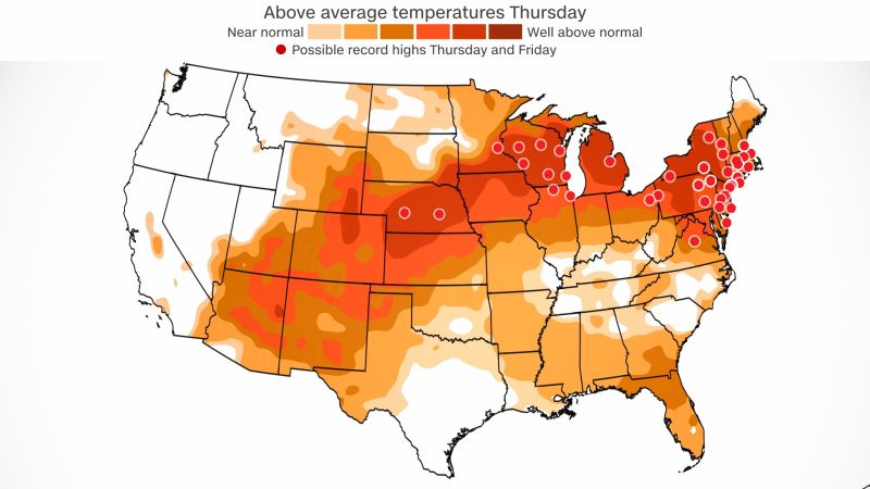
Summerlike heat will continue to build across the Midwest and Northeast through Friday, as temperatures soar to as much as 30 degrees above normal.
Nearly 90 daily records could be broken on Thursday and Friday, mainly across the Midwest and Northeast, and at least 50 record-high minimum temperatures could be set.
This comes after more than 35 daily record highs were broken on Wednesday from Nebraska to Delaware.
Sioux Falls, South Dakota, hit 92 degrees on Wednesday, shattering its old record of 85 set in 1908. Twin Cities, Minnesota, also broke a record after reaching a high of 88 degrees.
Record heat will continue
As an area of high pressure continues to build in the region, this will allow for temperatures to continue to warm and dry conditions to prevail.
“The dry airmass in place makes it quite easy to overachieve on highs and it is certainly possible that we approach 90 again in La Crosse,” the National Weather Service office in La Crosse, Wisconsin, said.
If La Crosse hits 90, that would shatter their old record of 80 degrees.
The heat will stretch as far as the Northeast and parts of New England, with New York City expected to top out in the mid-80s, which will come close to tying or breaking records for Thursday and Friday.
Cities including Chicago, Philadelphia, Washington and even Boston could set records this week.
[Very Warm, Summerlike Thursday!] Full sun & west breezes to bring a summerlike feel to today.
Many areas away from the coast are expected to see their first 80+ degree day since last Sept, with upper 80s in the CT Valley! It remains dry, so fire weather concerns will continue. pic.twitter.com/34KaVs0WRl
— NWS Boston (@NWSBoston) April 13, 2023
“Most areas away from Cape Cod, the immediate south coast and the North Shore should see their first 80 degree day since Sept/Oct 2022, and it is not out of the question that the Hartford and Springfield CT Valley areas could get very close to or reach 90,” the weather service office in Boston said.
Overnight lows are also staying warm, which doesn’t allow for much recovery from the heat. More than 75 record-high minimum temperatures could be set by Saturday morning.
Warm temperatures, along with low humidity levels and gusty winds, will create an elevated risk of wildfires.
Elevated fire risk
The weather service is warning of an elevated fire risk while the record warmth and dry conditions persist.
“Fine fuels in the form of dry or dead vegetation will be quite dry as well, and conducive to fire starts and fairly quick fire spread,” the weather service office in Mount Holly, New Jersey, warned. “This is particularly true in areas that have not received hardly any rainfall in the last 10 days, across much of Pennsylvania to northern and central New Jersey.”
Winds could gust as high as 35 mph, which will cause any fire that forms to spread quickly.
A wildfire has already broken out in New Jersey this week. The fire is now 75% contained, but it has already scorched roughly 4,000 acres and forced evacuations.
